Shetland HVDC Link 2: what is proposed for Boyne Bay and Boyndie Bay
Paid for by the public: as electricity billpayers, and as taxpayers standing behind the loans.
Everything below is read from published documents, mostly SSEN's, OfgemThe UK government regulator for gas and electricity, which sets how much network companies can charge billpayers. more ›'s and DESNZThe UK government department responsible for energy policy, including subsidy auctions and community fund guidance. more ›'s own; items with a fact-sheet entry carry its number. No preference is given between the two landfallThe point on the coast where a subsea cable comes ashore and connects to the onshore cable route. more › sites, and nothing here is an argument.
Moray Firth Energy: home · How the money works · The missing figures
What it is
The project carries three names and codes. SSEN calls it Shetland HVDCHigh Voltage Direct Current: the technology used for long subsea electricity cables, including the Shetland link. more › Link 2. OfgemThe UK government regulator for gas and electricity, which sets how much network companies can charge billpayers. more ›'s project code, from its 1 August 2024 consultation, is SHL256Ofgem's project code for this link: 'New 1.8GW HVDC link Shetland - Coachford'. more ›, "New 1.8GW HVDC link Shetland – Coachford". Ofgem's December 2024 decision describes the same row as "HNDFUE AC project: Shetland to Blackhillock".
FS 1Ofgem's 1 August 2024 consultation and SSEN's September 2024 announcement give the link as 1.8GW. SSEN's Autumn 2026 booklet, under its heading "HVDC Converter StationA large facility that converts electricity between the direct current used by a subsea cable and the alternating current used by the onshore grid. more ›", describes "A 2GW bi-poleAn HVDC link built using two conductors of opposite polarity, which can keep working at half capacity if one fails. more ›, 525kVThe voltage class of the bipole cable proposed for Shetland HVDC Link 2. more › HVDC link", beside an indicative design for a "2GW 525kV bipole converter station".
FS 2The route is subseaThe underwater section of the cable route, running from Shetland to the Aberdeenshire landfall. more › from Shetland, with landfallThe point on the coast where a subsea cable comes ashore and connects to the onshore cable route. more › proposed at Boyne Bay or Boyndie Bay, then about 30km of underground cable, crossing parts of Aberdeenshire and Moray, to the Strathbogie HubThe proposed converter and substation site north-east of Huntly where the onshore cable from the landfall would terminate. more › at CruchieThe two sites shortlisted for the Strathbogie Hub, north-east of Huntly. more › or Rivestone, north-east of Huntly.
FS 3SSEN's published timeline puts energisationThe point at which a new transmission link is switched on and carries power; SSEN's own timeline puts this project's energisation in 2035. more › in 2035. The stated feedback window for this landfall consultation closes 6 November 2026.
FS 5No capital cost has been published for this project by SSEN, Ofgem or NESOThe National Energy System Operator, the body that keeps Great Britain's electricity grid balanced minute by minute. more ›.
FS 7The company proposing to build it is SSEN Transmission, owned 75% by SSE plc and 25% by Ontario Teachers' Pension Plan of Canada, which paid £1,465.0m for its stake in November 2022.
FS 14Who pays: Ofgem classifies community benefitMoney a developer or network owner pays to communities near new infrastructure, recovered in full from billpayers. more › as a fully pass-through costA cost Ofgem lets a network company recover in full from billpayers, rather than paying for out of its own profit. more ›, recoverable from billpayersAnyone who pays an electricity bill. Most of the costs on this site are recovered this way, not from taxes. more › through network charges; the transmission ownerA licensed company that owns and builds the high-voltage electricity grid in part of Great Britain. more › earns a regulated return set by Ofgem (cost of equityThe profit margin Ofgem lets a regulated grid company earn on shareholders' money, built into billpayers' charges. more › 5.70% CPIH-real; WACC 5.74% semi-nominal, 4.67% CPIH-real; for the five years to March 2031).
FS 8 FS 12The two landfall sites
SSEN's own constraint and opportunity tables, read from its Autumn 2026 Aberdeenshire booklet. The same booklet contradicts itself on one point at Boyne Bay, and abbreviates a designation inconsistently at Boyndie Bay; both are given below.
Site 9: Boyne Bay
- SSEN's booklet lists as a constraint that the site "overlaps with the 'Cullen to Stake Ness Coast Site of Special Scientific InterestA nature conservation designation for a site of special scientific interest, notified by NatureScot. more ›'" and that "the Cullen to Whitehills Local Nature ReserveA nature conservation designation made by a local authority, lower than national designations like SSSI. more › is located within the site boundary". FS 44
- The same page lists, as a technical constraint, that "Caledonia Offshore wind farm export cables are making landfallThe point on the coast where a subsea cable comes ashore and connects to the onshore cable route. more › in this area" — and, as a technical opportunity on the same table, "No offshore cables or pipelines in the vicinity of the landfall". The same page lists the same Caledonia cables as both a technical constraint and, under "opportunities," as their absence. FS 43
- SSEN's booklet states: "There are two scheduled monumentsA nationally important archaeological or historic site given legal protection, listed with an SM number. more › within 2km of the Boyne Bay site and 'Craig of Boyne Castle' is located within the site." The site "is located within 1km of the Southern Trench Nature Conservation Marine Protected Area (NCMPA)".
- The booklet's constraints for Boyne Bay also include "Prime agricultural land" and "Area of high fishing activity (demersal gear, dredges, pots, traps, rod and line)"; "A new core path runs along the coast, in front of the HDD drilling compound"; and a "Temporary haul roadThe road a construction site would use for heavy vehicle access; named for both landfall sites but not yet confirmed. more › will need to be constructed from the nearby B9139 road, during the construction phase".
Site 10: Boyndie Bay
- The same booklet prints "Whitehills to Melrose Coast SSS" as a constraint for this site, on the same page where it elsewhere writes "Site of Special Scientific Interest" in full (SSSI). FS 44
- SSEN's own figure for the nearest scheduled monument is "Boyndie Old Kirk (SM5668) located approximately 140m to the south"; the booklet does not say which point of the site it is measured from. FS 46
- Boyndie Bay is a designated bathing water (SEPA, designated 1999, classified Good in 2025); the word "bathing" does not appear anywhere in SSEN's booklet. FS 45
- SSEN's booklet discloses that "Offshore wind farm cables and a telecommunication cable make landfall in Boyndie Bay", and names no operatorThe company that owns or charters out a ship, as distinct from the client paying to use it for a particular job. more › for them. FS 36A
The maps SSEN has published
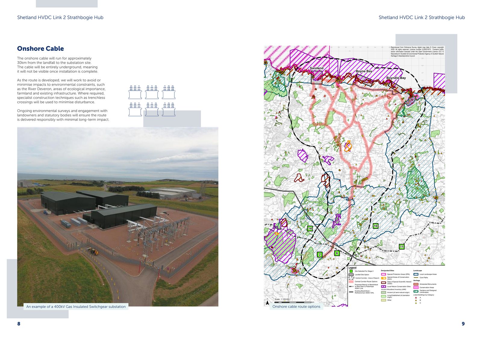
Two cautions before reading these. The outlines on the survey-block map (file 06 below) are labelled survey blocksAn area being surveyed ahead of construction, not the footprint of the landfall or any chosen route. more › in SSEN's legend, and SSEN's heading on the same page calls them "indicative landfallThe point on the coast where a subsea cable comes ashore and connects to the onshore cable route. more › areas"; they are not a landfall footprint, which has not been published. And the corridorA broad, mapped band within which a cable route could run; not a chosen route, width or list of affected land. more › maps (files 05 and 09) show a broad area of search with route options, at 1:125,000; they do not show a chosen route, a width, or which land is affected.
The five maps below are reproduced from SSEN Transmission's published consultation booklets and remain the copyright of Scottish and Southern Electricity Networks Transmission; where a map carries an Ordnance Survey base, that base is Crown copyright as marked on the original. They are shown here, unaltered and with the booklet and printed page given under each, for the purpose of criticism and review of the consultation. SSEN may ask for any of them to be taken down and this site will comply.
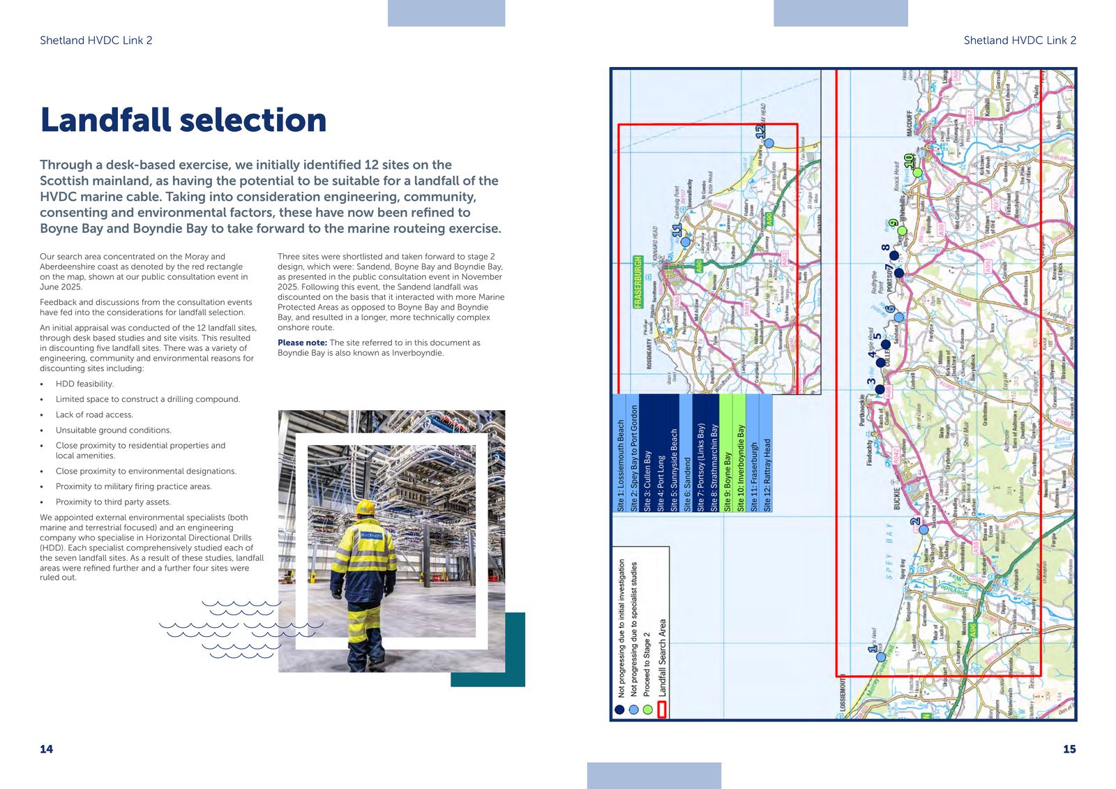
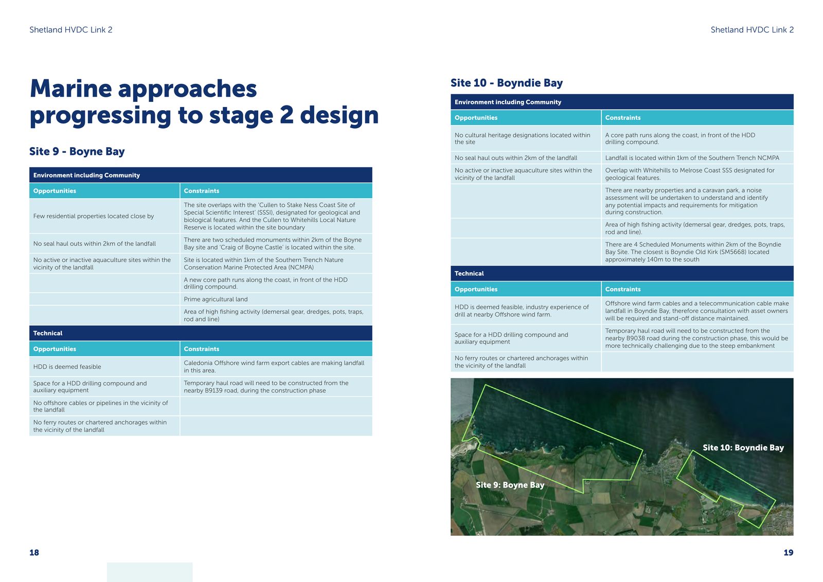
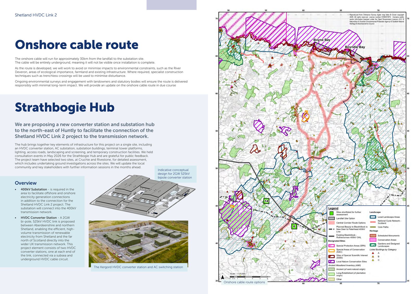
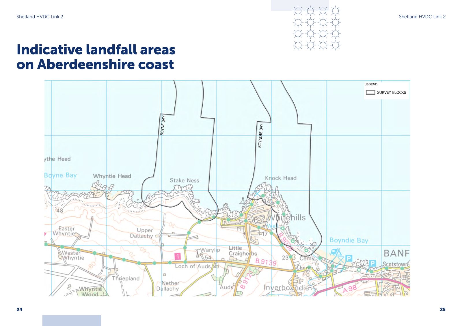
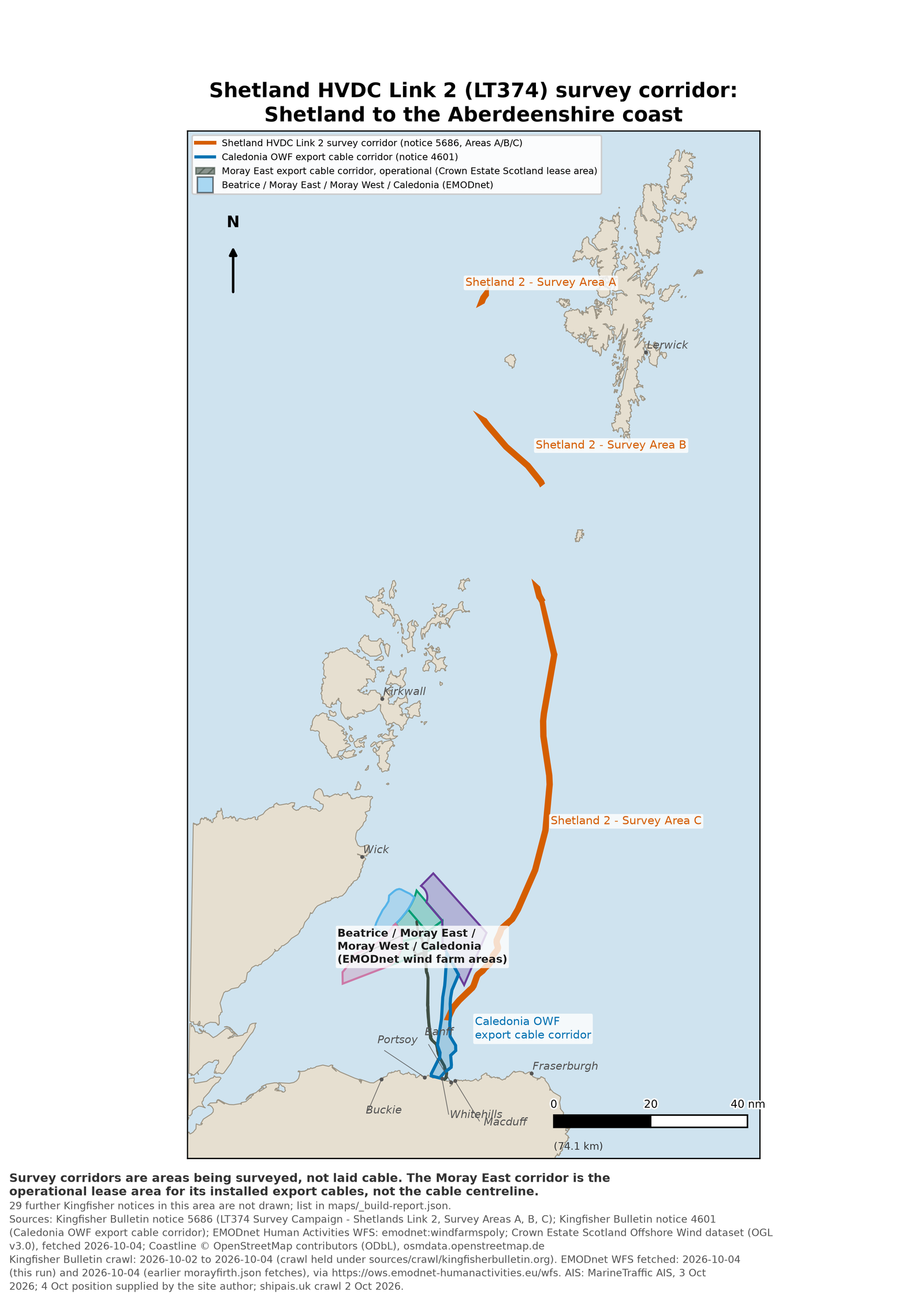
The survey corridor at sea
SSEN Transmission's marine cable route survey for the link was planned to begin outside the 12 nautical mile line on 23 February 2026 (SSEN's booklet says it started in February 2026) and was due to finish in August 2026. Reach SubseaThe underwater section of the cable route, running from Shetland to the Aberdeenshire landfall. more ›'s vessel VIKING REACH carries it out. The notice to fishermen gives the corridorA broad, mapped band within which a cable route could run; not a chosen route, width or list of affected land. more › as three survey areas, A, B and C, running from west of Shetland to a point about 13 nautical miles north of Macduff (computedLabels on the evidence register showing how strong a figure's source is: an official document, a press report, arithmetic, or an estimate. more › from the notice's coordinates). The chart below draws those coordinates exactly as published, with the Caledonia wind farm's export cable corridor and the wind farm areas for comparison.
Community funding: what applies on this coast
Under DESNZThe UK government department responsible for energy policy, including subsidy auctions and community fund guidance. more ›'s own guidance, buried cable is out of scope of the community fundsMoney a developer or network owner pays to communities near new infrastructure, recovered in full from billpayers. more › for transmission infrastructure; the in-scope list is "applicable only for overhead HVDCHigh Voltage Direct Current: the technology used for long subsea electricity cables, including the Shetland link. more › transmission". On the published rules, this coast's community fund entitlement for the buried cable is £0.
FS 30The electricity bill discount scheme is closed to buried cable on the face of the statute: Electricity Act 1989The UK statute that underpins transmission licensing, the bill discount scheme and compulsory acquisition powers for projects like this one. more › s.38A(3) requires qualifying works to be "wholly or partly above the ground". The buried cable itself cannot qualify, and Shetland HVDC Link 2 is not on DESNZ's 12 August 2026 list of projects expected to be eligible.
FS 32 FS 24OfgemThe UK government regulator for gas and electricity, which sets how much network companies can charge billpayers. more › classifies community fund spending as a fully pass-through costA cost Ofgem lets a network company recover in full from billpayers, rather than paying for out of its own profit. more ›: transmission ownersA licensed company that owns and builds the high-voltage electricity grid in part of Great Britain. more ›, including SSEN, may recover 100% of eligible community fund costs from billpayersAnyone who pays an electricity bill. Most of the costs on this site are recovered this way, not from taxes. more ›, so that they are "not financially disadvantaged" by paying them.
FS 8In the same council area, for one converter stationA large facility that converts electricity between the direct current used by a subsea cable and the alternating current used by the onshore grid. more › site, SSEN set the Eastern Green Link 2 Peterhead Local Fund at £2,159,444 — 4.07 times the £530,000 guidance rate for a converter station.
FS 34The North Aberdeenshire Local Fund is set at £8,845,000, built from other transmission projects in the area. No community council covering Banff, Whitehills or Boyndie is on its list of benefiting areas, and Shetland HVDC Link 2 contributes nothing to it.
FS 35What has not been published
Searching all seven Shetland HVDCHigh Voltage Direct Current: the technology used for long subsea electricity cables, including the Shetland link. more › Link 2 consultation booklets for "joint bayAn underground chamber where lengths of cable are jointed together; its size and number are not published for this project. more ›", "trench width", "working widthThe width of land needed during construction for the cable trench, access and storage; not published for this project. more ›", "easementA right to use a strip of someone else's land for the cable, without owning it outright. more ›", "corridorA broad, mapped band within which a cable route could run; not a chosen route, width or list of affected land. more › width", "HGV" and "burial depth" returns zero hits for every term. FS 50
Also absent from every source held for this page: any capital cost FS 7; the subsea cableThe underwater section of the cable route, running from Shetland to the Aberdeenshire landfall. more › length; the cable count; any contract value; grid references, hectares, site-specific building heights (only an indicative conceptual converter design is dimensioned) and distance to nearest homes for the Cruchie and RivestoneThe two sites shortlisted for the Strathbogie Hub, north-east of Huntly. more › hub sites; any community benefitMoney a developer or network owner pays to communities near new infrastructure, recovered in full from billpayers. more › figure for Shetland HVDC Link 2 in Aberdeenshire; the consenting route for the subsea cable, the landfallThe point on the coast where a subsea cable comes ashore and connects to the onshore cable route. more › and the onshore cable, which the booklets do not name; whether a new overhead line is needed at the hub (SSEN lists "terminal tower platforms" among the hub's elements but does not say); and the size and position of the permanent link-pillar cabinet SSEN says will sit in a fenced area at the landfall. FS 51
The committee papers for a commercial lease between SSEN Transmission and a Tier 1 contractor at Walker Court, Aberchirder (Banff and Buchan Area Committee, 16 June 2026) — the report, site plan and impact assessment — are flagged restricted in the council's own metadata; only the minute is published. FS 52
Deadlines and rights
- 6 Nov 2026
- SSEN's stated feedback window for the Aberdeenshire landfallThe point on the coast where a subsea cable comes ashore and connects to the onshore cable route. more › closes. It is a developer consultationSSEN's feedback window is a developer consultation it runs itself, not a statutory objection period with a right of appeal. more ›, not a statutory objection period. FS 53
- 31 Dec 2027Ofgem's Price Control Deliverable date by which SSEN must submit all material planning consents for this project. more ›
- OfgemThe UK government regulator for gas and electricity, which sets how much network companies can charge billpayers. more ›'s Price Control Deliverable date for submission of all material planning consents. SSEN's own published timeline puts the planning application in 2027 and the marine licenceThe consent needed under the Marine (Scotland) Act 2010 for works affecting the sea bed or marine environment. more › submission in 2028. FS 54
- Determining regime
- For the hub only: SSEN's May 2026 booklet says Strathbogie HubThe proposed converter and substation site north-east of Huntly where the onshore cable from the landfall would terminate. more › needs planning permission from Aberdeenshire Council under the Town and Country Planning (Scotland) Act 1997. No booklet names the authority or statute for the subsea cableThe underwater section of the cable route, running from Shetland to the Aberdeenshire landfall. more ›, the landfall or the onshore cable. FS 51
- Information rights
- SSEN Transmission handles requests for environmental information under the Environmental Information (Scotland) Regulations 2004. If its internal review does not settle a request, the appeal goes to the Scottish Information CommissionerThe regulators for information rights complaints: the UK Information Commissioner (ICO) for Ofgem and NESO; the Scottish Information Commissioner for SSEN Transmission, which handles requests under the Scottish regulations. more ›. FS 55
Two further dates carry no fact-sheet number: SSEN says it hopes to share "a plan for a least constrained landfall, a proposed underground cable route, and a least constrained site for Strathbogie Hub, within the coming months"; and Aberdeenshire's next Local Development PlanThe statutory land use plan a council updates periodically; an allocation in it can trigger statutory blight rights. more › is expected to be published in early 2029. Compulsory acquisitionThe power to acquire land or rights over it without the owner's agreement, available under Schedule 3 to the Electricity Act 1989. more › powers, if ever used, sit under Electricity Act 1989The UK statute that underpins transmission licensing, the bill discount scheme and compulsory acquisition powers for projects like this one. more › Schedule 3. Electricity Act 1989, Sch. 3
SSEN, Shetland HVDCHigh Voltage Direct Current: the technology used for long subsea electricity cables, including the Shetland link. more › Link 2 – Aberdeenshire coast landfallThe point on the coast where a subsea cable comes ashore and connects to the onshore cable route. more › options consultation booklet, Autumn 2026. SSEN, Shetland HVDC Link 2 Public Information Event booklet (landfall and northern hub), Summer 2026. SSEN, Shetland HVDC Link 2 – Landfall Selection, October 2025. SSEN, Strathbogie HubThe proposed converter and substation site north-east of Huntly where the onshore cable from the landfall would terminate. more › consultation booklet, May 2026. OfgemThe UK government regulator for gas and electricity, which sets how much network companies can charge billpayers. more ›, tCSNP2Ofgem's transitional Centralised Strategic Network Plan 2 process, under which this project was assessed and put in the delivery track. more › consultation, 1 August 2024, and tCSNP2 decision (OFG1164), 11 December 2024. Ofgem, Community FundsMoney a developer or network owner pays to communities near new infrastructure, recovered in full from billpayers. more › for Electricity Transmission Infrastructure Pass-ThroughA cost Ofgem lets a network company recover in full from billpayers, rather than paying for out of its own profit. more ›: Guidance, 1 April 2026. Ofgem, Decision on RIIO-3Ofgem's current five-year price control, which sets how much transmission companies can charge billpayers and what return they earn. more › licence modifications — reasons and effects, 3 February 2026. Ofgem, RIIO-3 Final Determinations — Finance Annex, 4 December 2025. DESNZThe UK government department responsible for energy policy, including subsidy auctions and community fund guidance. more ›, Community Funds for Transmission Infrastructure: Guidance. SEPA bathing water data, Inverboyndie. DESNZ, Electricity bill discount scheme for transmission network infrastructure: expected eligible projects, 12 August 2026. Electricity Act 1989The UK statute that underpins transmission licensing, the bill discount scheme and compulsory acquisition powers for projects like this one. more › s.38A and Schedule 3The power to acquire land or rights over it without the owner's agreement, available under Schedule 3 to the Electricity Act 1989. more ›. UK Environmental Information RegulationsLegal rights to request information from public bodies (FOI) or environmental information from a wider range of bodies (EIR). more › 2004 (SI 2004/3391). SSE plc Annual Reports 2023 and 2026. SSEN Transmission news release on the second Shetland link, September 2024; SSEN Transmission project pages and community fund pages (Eastern Green Link 2 Peterhead Local Fund; North Aberdeenshire Local Fund). Kingfisher BulletinA fisheries-liaison service that publishes notices warning fishing vessels about offshore works, including which vessels are involved. more › notices 5686 and 4601. EMODnet Human Activities; Crown Estate Scotland Offshore Wind dataset; OpenStreetMap. Aberdeenshire Council committee records (Banff and Buchan Area Committee, 16 June 2026) and Local Development PlanThe statutory land use plan a council updates periodically; an allocation in it can trigger statutory blight rights. more › 2029 page. Full citations with file and line number are in FACT-SHEET.md.